p18i4gq3d9dtnnc1ikb1nu41uju6.jpg
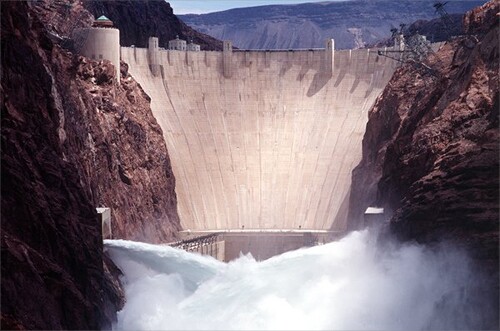
Before the 14-year drought began, the Bureau of Reclamation tested new jet-flow gates, sending a torrent of water from Lake Mead downstream in 1998. Twelve obsolete needle valves were replaced with the jet flow gates in the outlet works to release 73,000 cubic feet per second without requiring use of the spillways. Now, the bureau is installing five wide-head turbines that will allow the dam to keep generating electricity as the lake level falls. (Image: U.S. Bureau of Reclamation) Read the full story here.
p18i4gq3d916gr1bv5pgn1r9hqh2c.jpg
In this photo from space in 2000, water levels in Lake Powell were relatively high, and the water was a clear, dark blue. The sediment-filled Colorado River appeared green-brown. As drought began to take effect, the declines were first apparent in the side canyons, which thinned and then shortened. This year, the Bureau of Reclamation will for the first time decrease the amount of water that flows to Lake Mead from Lake Powell, 180 miles upstream. (Image: NASA)
p18i4gq3d9otm18cd1t001tag1uus9.jpg
Lake Mead as seen from space in 2006. The reservoir's water level has fallen below the drought level -1,125 feet above sea level — three times since Hoover Dam was opened in 1936, according to the U.S. Bureau of Reclamation. From 1953 to 1956, the water level fell from 1,200 to 1,085 feet. From 1963 to 1965, the water fell from 1,205 to 1,090 feet. In June 2010, the lake was at 39% of its capacity, and on Nov. 30, 2010 it reached 1,081.94 feet, setting a record monthly low. (Image: NASA)
p18i4gq3dd17rq1fls1sfr10tf1qgf.jpg
The Upper Colorado River Basin experiences significant year-to-year variations, according to the U.S. Geological Service. During the 14-year period 2000 to 2013, however, the unregulated inflow to Lake Powell was above average in only 3 out of the past 14 years. The period 2000-2014 is the lowest 14-year period since the closure of Glen Canyon Dam in 1963, according to the USGS. Lake Mead is typically at its highest yearly elevation in the late fall and early spring. (Image: Arizona Power Authority)
p18i4gq3d91gl8denseq40k1a7nb.jpg
Created by Act of Congress in 1964 as the nation's first national recreation area, Lake Mead National Recreation Area straddles nearly 140 miles of the old Colorado River channel between Nevada and Arizona. The recreation area was closed to tourists for 17 days in 2013 due to the federal government shutdown. Losing 14,500 visitors per day cost the region about $17 million, according to official estimates. At the Hoover Dam, the visitors center remained open because its revenue was not dependent on the federal funds. (Image: National Park Service)
p18i4gq3d9lat18iiinf19bbcj6a.jpg
OLYMPUS DIGITAL CAMERA
The water level in Lake Mead is lower than it has been in over 40 years, creating the telltale "bathtub rings" on the canyon walls. Colorado River runoff over the last decade starting in 1998 has been far below normal. In December 2007 new guidelines adjusted allocations in the event of shortages. The guidelines through 2026 are designed to allow the system operators to gain experience with low-reservoir conditions. (Image: Bureau of Reclamation)
p18i4gq3d9141e1i002ck1nj91pnk8.jpg
Hoover Dam's four intake towers, built into the sides of the original Black Canyon of the Colorado, are each about 30 stories tall. Combined, the towers can take in 118,000 cubic feet of water per second, of which 32,000 cubic feet per second is used for power generation. The water is diverted to the generating plant through 30-foot concrete-lined tunnels called penstocks.
p18i4gq3dd10ural41u3dj9h1cncg.jpg
Inside Hoover Dam are 17 turbines — nine on the Arizona side and eight on the Nevada side — plus two small units used to create power for the plant itself. The force of the water spins the turbines, which, in turn, spin magnets past stationary coils of copper wire. The dam generates, on average, about 4 billion kilowatt-hours of hydroelectric power each year for use in Nevada, Arizona, and California — enough to serve 1.3 million people. (Image: U.S. Bureau of Reclamation)
p18i4gq3d9bfkm3g1qro1icato37.jpg
Lake Mead begins to fill against the upstream face of what was originally known as the Boulder Dam in 1935. While President Franklin Roosevelt came to the dedication on Sept. 30, 1935, former President Herbert Hoover, for whom the dam was later named, was not invited. (Image: U.S. Bureau of Reclamation)
p18i4gq3d93ck187q47gqnl3eud.jpg
Las Vegas is seen at night from space in this image from NASA's Earth Observatory. Without the federally funded Hoover Dam, metropolitan Las Vegas would not have had the power and water to grow to its current population of nearly 2 million. From 1939 to 1949, the dam's power plant was the world's largest hydroelectric installation. Under the 1922 Colorado Compact, water rights to the river were split evenly between the upper-basin states of Utah, New Mexico, Colorado and Wyoming and the lower-basin states of Arizona, Nevada and California. However, the compact failed to anticipate the rapid population growth in the lower basin states. Nevada has the smallest water allocation in the lower basin. (Image: NASA)
p18i4gq3d9um21qln1cf1omntfh5.jpg
The Central Arizona Project, a 336-mile canal that diverts water from the Colorado River at Lake Havasu, is the largest and most expensive aqueduct ever built in the United States. The CAP was created by the Colorado River Basin Project Act, signed by President Lyndon B. Johnson on Sept. 30, 1968. In exchange for supporting the project in the 1960s, California's congressional delegation won senior rights to the Colorado water. In the event of rationing in 2015, Arizona's allotment of water could be reduced while California's would be unaffected. The CAP, built with $4 billion of federal funds, was declared substantially complete in 1993. (Image: U.S. Bureau of Reclamation)
p18i4gq3d91b9e1obkcpnmef19ufe.jpg
Intake No. 3 is a 3-mile tunnel that will allow the Southern Nevada Water Authority to draw water from Lake Mead in severe drought. Begun in 2008, the project required a massive boring machine to chew through solid rock underneath Lake Mead and an intake structure two and a half miles offshore. More than 1,000 concrete truck loads were transported to the intake site on 143 barge trips. Scheduled to open this year, the tunnel will allow Las Vegas and other cities in Southern Nevada to divert water from Lake Mead to treatment plants, even if the reservoir's water level falls to 1,000 feet above sea level. The third intake is part of a $2.3 billion capital improvement project.
p18i4gq3d91u5m17kg1ght1fskk654.jpg
Photo showing current view of Hoover Dam.
Stephens, Alexander/N/A
The Mike O'Callaghan-Pat Tillman Memorial Bridge bypassed the narrow Hoover Dam road on U.S. 93 for the first time when it opened in 2010. At 840 feet, it is the second highest in the U.S. behind the Royal Gorge Bridge in Colorado. The total estimated project cost was $240 million, including $100 million from the federal government, $20 million each from Arizona and Nevada, with the remainder bond-financed by the two states. The Transportation Equity Act for the 21st Century, signed into law by President Clinton on June 9, 1998, provided $41 million for the bridge under the High Priority Projects Program. (Image: FHWA/CFLHD).
MORE FROM BOND BUYER